CBID hears ideas on downtown Fort Smith connections
by January 18, 2024 5:12 pm 1,208 views
Galen Hunter, with MAHG Architecture, on Thursday (Jan. 18) discusses downtown Fort Smith connections with members of the Central Business Improvement District.
Connectivity in downtown Fort Smith with attractions along the Arkansas River is the main focus of a study by MAHG Architecture for the Fort Smith Central Business Improvement District.
The CBID board agreed during the summer to hire MAHG for a study to help determine what future projects could best help downtown Fort Smith thrive. MAHG reps met with the CBID board in November to discuss ideas. They met again Thursday (Jan. 18) share their identified areas of focus.
Galen Hunter with MAHG said after further analysis of the CBID and the points raised at the last meeting, they had identified a focus on connection – with the riverfront and with making pathways to visually connect Rogers Avenue with Garrison Avenue and with the east end of Garrison Avenue at Cisterna Plaza to Brunwick Place to the north.
“Coming to the west, there are different ways to get down to the riverfront and where we have people coming from,” Hunter said. “They may park in the Farmer’s Market parking lot and go down, but we also hope they are coming up Rogers Avenue from the hotels and large parking lots. So we need to see how they can do that.”
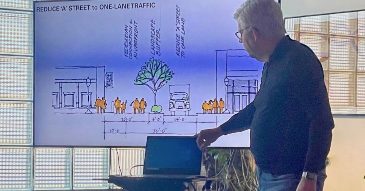
Plans for accessing the riverfront from the Farmer’s Market parking lot at Second Street and Garrison Avenue could be made a viable option by changing A Street from two lanes to one lane from the point it diverges from Riverfront Drive for a few blocks, allowing for a devoted pedestrian lane.
A Street is 30-feet wide with extra space on either side, Hunter said, which is more than is needed for two lanes. If the southern most lane was closed to traffic, there could be space for a 20-foot pedestrian promenade, a 14-foot lane for traffic and space for a barrier between the two.
“There is often lots of traffic on this road, but seldom is there traffic in both lanes,” Hunter said.
If the promenade could connect the Riverfront Events Building on Riverfront Drive, pedestrians could then utilize the Greg Smith River Trail to access other attractions along the river, including the U.S. Marshals Museum and the planned Children’s Museum. It would be important to make the entrance to the pedestrian promenade visible from Garrison Avenue with a gateway at the intersection of Second and A streets, Hunter said.
It would also be good to have a connector from Ross Pendergaft Park to the Farmer’s Market with mid-block crossings and small islands in the street, which could add protection for pedestrians, Hunter said. Another MAHG idea is to utilize parking on Rogers Avenue, and have a gateway at the end of trolley tracks.
“It would be very easy to put up signage and develop a one-block path to go under the bridge,” Hunter said.
Using colored light activations and selfie spots could make the area “uncomfortable to live but fun to walk through,” which would discourage homeless camps and make the area more attractive and safe for pedestrians, he said.
For better connecting Rogers and Garrison avenues, Tim Varner with MAHG presented options including a Court Street corridor, a connection by Prohibition Bar at 701 Rogers Ave., and a connection beside the city parking garage on Rogers Avenue. String lights, an art walk and places to sit and congregate beside Prohibition Bar would make the corridor safe and attractive to pedestrians, he said
“First and foremost, there are a lot of people coming from parking lots and hotels on the south side of Rogers Avenue. We need good, safe and apparent ways to get them to Garrison,” Varner said. “There could be a real wow factor to it.”
Key components of any corridor would include visible pedestrian entries, places to sit down and rest, lighting and trees. A connection from Cisterna Park at 1001 Garrison Avenue to Brunwick place on 10th Street could be somewhat easy to accomplish, according to the MAHG presentation. Devin Tabor with MAHG said a project would need to use what is already there and develop an understood line between the two.
“We could create a pedestrian promenade through here. There is a road not used for anything anyway. We could add nice trees, benches, keeping a lot the same, but maybe adding more brick spaces, give it a little more town square kind of feel,” Tabor said, noting this idea would keep the fountain and statue in place, adding seating and chess tables and midblock crossing.
The MAHG representatives said they will come to the CBID board in February with definition and scope to proposed projects.
“Then we can put them in front of you to rank these projects as to which ones are most needed and most plausible,” Hunter said.
After that, MAHG and the CBID could develop an action plan for short-term projects that will take one to two years, median projects that will take three to four years and long-term projects that will take five to seven years.