Arkansas Forestry Division ups wildfire danger risk level as temperatures soar statewide
by July 18, 2022 10:16 am 1,910 views
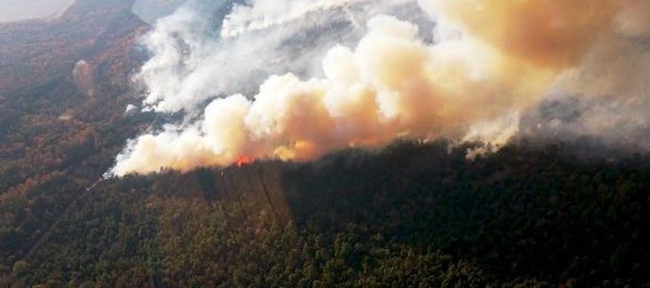
Parts of Arkansas received some much-needed rain during the weekend, but the overall wildfire threat level has gone up significantly in July. And, the forecast predicts even hotter and drier conditions during the next week.
The Arkansas Department of Agriculture’s Forestry Division has increased the wildfire danger risk level designations for all 75 counties during the past two weeks. Twelve counties in Northwest Arkansas were raised to the “high” risk level, and the remaining counties were rated as being at a “moderate” risk for wildfire danger.
Additionally, 53 counties have been placed under a burn ban by local county judges.
“These 90-to-100-degree days with little or no rain have led to extremely dry conditions across the entire state,” said State Forester Joe Fox. “We are seeing an increase in the number of wildfires and their intensity, and that’s a trend that will continue until we see significant rainfall statewide.”
Temperatures are projected to soar above 100 degrees each day this week starting on Tuesday, according to the National Weather Service. No rain is predicted through Sunday. Long-term forecast models indicate that the same pattern of no rain and triple digit temperatures could extend another week beyond.
All counties in the northern third of the state are in phase one drought status, according to NWS. Most counties in Northeast Arkansas and a few in extreme Southwest Arkansas are in phase one.
The rest have been classified in the abnormally dry category. Parts of Fulton, Sharp, and Randolph counties have been classified in phase two or severe drought.
The Forestry Division maintains a county-by-county Wildfire Danger map with four risk levels: low, moderate, high, and extreme. Risk levels are determined by drought status and long-term weather forecasts and are defined by how easily fires can start and how hard they are to contain.
Low risk means that fuels do not ignite easily and that weather conditions will lead to slow, easy to control fires. Moderate risk means fires can start from accidental causes. They may not become serious, but caution should be taken.
High risk means that fires ignite easily and spread quickly. Unattended brush fires and campfires are likely to escape and may become serious if not attacked early. Counties in the extreme category can expect fires to start quickly, spread furiously, and burn intensely. Every fire started has the potential to become large.
In addition to heightened risk levels, 53 Arkansas counties have been placed under a burn ban by local county judges. Burn bans primarily prohibit activities that involve an open flame. This includes fireworks, campfires, trash burning, open flame grilling, and prescribed or controlled burns. Robert Murphy, Director of Emergency Services for the Forestry Division, recommends taking additional precautions when driving or operating machinery.
“It’s important to remain cautious when driving through or working in dry grass,” Murphy said. “Trucks, ATVs, hay balers, and other vehicles can easily start fires by causing sparks over dry grass.”
Wildfires in Arkansas have been on the decline in recent decades in terms of the number of fires and acres impacted. Since 1935, the Forestry Division has tracked wildfires.
In 1952, at least 7,326 fires were reported, the most ever recorded. In 1960, about 421,000 acres burned, the most ever. In 2020, there were 221 wildfires in the Natural State that burned almost 6,900 acres.
The Forestry Division is asking anyone who see fires to report them by calling 1-800-468-8834 and to avoid flying drones in the area. When drones are present, those fighting the fires are unable to perform detection flights or fly single engine airtankers (SEATs) to drop water.