Sunken Lands Water Trail dedicated in Northeast Arkansas
by May 12, 2021 11:50 am 2,010 views
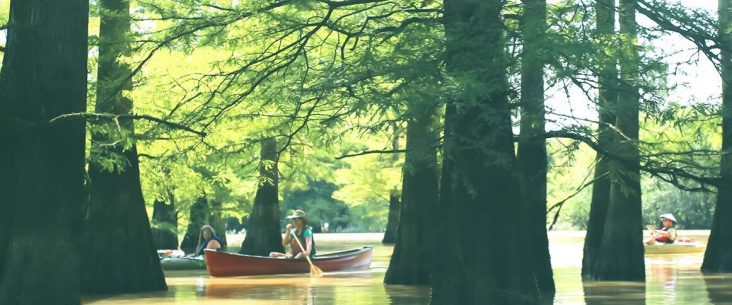
The Sunken Lands Water Trail, created by the Arkansas Game and Fish Commission, the St. Francis Lake Association, and the Trumann Area Chamber of Commerce, shouldn’t exist. It took one of the most famous geological events in history to help create it.
Gov. Asa Hutchinson recently dedicated the state’s latest waterway trail in Poinsett County.
There is enough history, heartbreak, and political intrigue per square foot in the 37,000-acre patch of Northeast Arkansas to keep genealogists, geologists, foresters, engineers, historians, and novelists busy for years, Hutchinson said. The Sunken Lands Water Trail, which is a path for paddlers rather than pedestrians, is the Game and Fish Commission’s 14th water trail.
“Sunken Land Water Trails is another jewel in the Natural State’s crown, a place packed with history and primed for the future,” the governor said.
How this unique feature in the waterway was created stretches back before the Natural State was even a state.
Sunken Lands takes its name from the earthquakes in the early 1800s when the land literally sank and disappeared under water. The quakes began in December 1811 and continued through March 1812. Land in the counties of Craighead, Mississippi, and Poinsett disappeared.
The series of quakes, registering more than an 8 on the Richter Scale, are among the most powerful ever documented in North America. It was widely reported that the quakes, which centered near New Madrid, Mo., shook church bells as far away as Boston.
Eyewitnesses wrote that the ground moved like waves on the land, and that the earth burst open and sent up huge plumes of water and sand. Where forests and hills once dominated, only flooded land remained. The quakes dug chasms as deep as 50 feet and dumped land into the St. Francis River, Hutchinson said.
Many who survived the quakes lost everything they owned and moved away. Some who moved west settled at Crowley’s Ridge, the only high ground left.
For more than 100 years, Arkansans worked to make something of the waterlogged regions. Their ingenuity produced the Steep Gut Floodway with a lock and sluiceway in 1926, and Marked Tree Siphons, which went into operation in 1939. A newspaper reporter for the Marked Tree Tribune wrote that the siphons lifted “the whole river 30 feet across a dam and deposited it on the other side.”
The siphons and the floodway controlled and drained the water, and allowed towns such as Lake City, Turrell, Lepanto, Marked Tree, Tyronza, and Trumann to thrive, Hutchinson said. A loop off U.S. 63 runs through much of the Sunken Lands region, including the St. Francis Sunken Lands Wildlife Management Area, famous for its hunting and fishing. The Marked Tree Siphons is on the National Register of Historic Places.
More than 200 years later, Arkansas has found another use for the waterway by creating the water trail, which officials expect will draw thousands of tourists annually. The St. Francis Sunken Lands Water Trail was conceived by local officials and nature lovers, who were assisted in their dream by the Arkansas Game and Fish Commission.
Game and Fish Biologists Jeremy Brown and Jessica Holman spent hundreds of hours on the project. Chris Colclasure, deputy director of Game and Fish, Neal Vickers, retired executive director of the Trumann Area Chamber of Commerce, and U.S. Rep. Rick Crawford, R-Jonesboro, supported the project.