Farmers assess damage after history-making Tropical Storm Laura sweeps state
by August 30, 2020 10:41 am 1,377 views
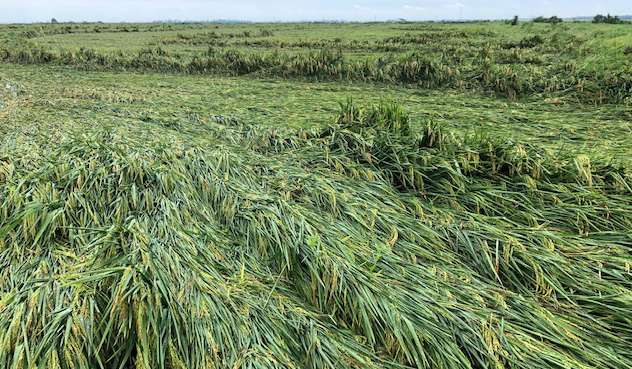
Flattened, or lodged, rice between Crockett’s Bluff and Arkansas Highway 1 in Arkansas County. (Photo: UA System Division of Agriculture by Phil Horton)
Arkansas farmers are still calculating the damage in the wake of Tropical Storm Laura. The storm that hit the state Thursday (Aug. 27) produced gushing rains, high winds and a multitude of tornadoes in Northeast Arkansas. Originally a hurricane, Laura was the first storm in state history to produce a tropical storm warning in the Natural State, according to the National Weather Service
Photos taken by extension personnel show swaths of flattened, or “lodged” plants in the heart of rice country. Jarrod Hardke, University of Arkansas Agriculture Extension rice agronomist, said in an early round of assessments, it seems “rice damage is luckily minimal.”
“The damage appears worse in the south and lessens as you move north,” he said. “The closer to harvest the field is, the worse the impact, but cultivar, seeding rate and fertility are all impacting factors.”
Matthew Davis, extension staff chair in Jackson County, said soybeans in his county seemed to have been the hardest hit.
“Soybeans have a lean to them,” he said. “Some that were 4 feet tall are around 2 feet tall now.”
Jeremy Ross, extension soybean agronomist, said, “What I’ve seen are fields with tall soybean plants that have a severe lean — they’re not completely flat.
“These fields should stand back up, but not completely,” he said. “They will have a lean the rest of the year. There shouldn’t be any yield impact, but they will be impossible to scout.”
In White County, Extension Agent Jan Yingling said she found roads covered with water and patches of fields leaning, but “my farmers have told me that most everything is still standing and they feel like they were spared.”
In Ashley County, along the Arkansas-Louisiana border, extension county chair Kevin Norton said about 90% of the county’s cotton and soybean acreage had “some degree of lodging.”
“Cotton seems to be the hardest hit,” Norton said. “Corn is all over the board. I would estimate that 60 percent of corn acreage has some degree of lodging, ranging from 5 to 95 percent.”
Cross County Extension Staff Chair Rick Wimberley, said rice and corn in his county was still standing for the most part, but soybeans were hit hard.
“I saw a lot of fields laying down. Don’t know if they can stand back up or not,” he said.
Wimberley, who is also a volunteer firefighter and a storm spotter, said “there was either a small tornado or straight line winds that broke tree limbs, uprooted trees, and blew down the city pavilion at Hickory Ridge.”
“An airplane hangar was heavily damaged there, along with one aircraft that was undergoing maintenance,” he said. “The communications tower at the Hickory Ridge Fire Department was blown down along with a power pole. Many of the fields along a line from Hickory Ridge to approximately one mile east of Penrose are starting to flood. I expect floodwater to increase in the lower section of the county in this area the next couple of days because of poor drainage along a tributary know as Second Creek that flows into northern St. Francis County. This area has a history of flooding with heavy rains.”
In Randolph County, extension staff chair Mike Andrews said Laura destroyed a farm shop near Biggers, flattened half a field of soybeans and even flipped a few peanut vines out of the soil. Even so, Andrews said “I think we made it through way better than I thought the crops would.”
Bill Robertson, extension cotton agronomist, said that “wind did push cotton over, especially the taller cotton, but I hope a lot of it will stand back up.” He also noted some plants simply becoming entangled with one another.
The circular nature of Laura’s winds across the state left clues in the patterns of field damage; which was dependent upon how the rows were oriented.
“Where the wind was blowing across the rows, there were more issues,” Robertson said. “In Lee County, the winds were more from the south, so north-south rows fared better. In Lonoke County, winds were more from the east, so east-west rows looked better there.”
“The big issue is forecast rain with upcoming weather fronts,” he said. “We need things to dry. If it stays wet, it will rot a lot of crop.”
Dan Koch, meteorologist for the National Weather Service in North Little Rock said the storm was historical from at least one perspective.
“We had so many questions about this yesterday from all walks of life,” he said. He explained that “it’s not that we never had tropical storm force winds, but it was a National Weather Service policy that we never issue tropical storm warnings this far inland. This was the first time we had the chance to issue one of those.”