Little Rock port officials planning for the worst, call Arkansas River conditions ‘unsafe’
by May 29, 2019 3:58 pm 2,412 views
As the Arkansas River reaches historic levels in central Arkansas, Little Rock Port Authority officials have halted all barge traffic amid concerns that waters will crest and create dangerous conditions on the waterway transportation system.
Following flooding upriver along the Arkansas River system, known officially as the McClellan-Kerr Arkansas River Navigation System, central Arkansas officials are anxiously awaiting word from the U.S. Army Corps of Engineers if the river will crest and overflow the levee protecting the sixth-longest tributary in the U.S.
“It is ever-changing. We are basically taking it day by day. Right now, we are no longer working barges because it is unsafe,” said Bryan Day, executive director of the city’s self-funded port and industrial park authority. “We’ve got 85 barges now stored in our Slackwater Harbor to get them out of the flow of the river.
“And right now, we are working to secure our warehouses. We are planning for the worst. We don’t know if the river will come across the bank [because] … the forecast from the Corps of Engineers changes every day,” continued Day.
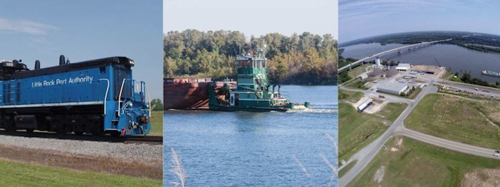
The 445-mile McClellan-Kerr stretches across Arkansas from the confluence of the Mississippi River to the Port of Catoosa near Tulsa, Okla. The controlled waterway has 18 locks and dams, with 13 in Arkansas and five in Oklahoma. The river also has five ports in Pine Bluff, Little Rock, Fort Smith, Muskogee, Okla., and the Port of Catoosa.
Earlier this year, the local port authority celebrated the completion of the first phase of a $10.5 million harbor expansion project, first announced in July 2016. At 4,500 feet long, 15 feet deep, 320 feet wide, the Slackwater Harbor is an inland channel from the Arkansas River providing direct river access. The two-phase expansion, which is funded by the U.S. Department of Transportation’s TIGER grant program, will further develop the 190-foot dock area with access for two barges on both sides of the river harbor.
While the Port of Little Rock is a central hub for rail, waterway and highway access for top Arkansas manufacturers and industrial clients, Day said it is also home to more than 40 international companies that can ship product from barge to railcar or vice versa.
DRY SIDE OF LEVEE SAFE FOR NOW
Under the port authority’s current emergency flooding plan, Day said the authority has secured all the barges on the harbor and all the equipment and materials along the dock. He said that plan could easily change tomorrow as he gets daily updates on river levels from the Corps of Engineers.
Concerning the existing companies and manufacturers in the industrial park such as LM Windpower, Welpsun Pipes, Novus International, Hormel Foods and Schueck Steel, Day said most are on the “dry side” of the levee that protects the land along the Arkansas River. Those four or five companies on the “wet side” of the levee, including Logistic Services Inc. and Delek Ethanol, are being closely monitored, he said.
“As of yesterday, we don’t believe the water will crest the banks,” said Day. “But we are communicating with those companies along the river’s edge. The majority are on the dry side and it should be a non-issue for most of them.”
During a press conference at Camp Robinson on Wednesday (May 29), Gov. Asa Hutchinson said he was increasing emergency funding from $100,000 to $350,000 to deal with ongoing and historical flooding levels along the Arkansas River system.