Aerospace, agriculture combine in data research project at Arkansas State University
by September 6, 2020 11:59 am 2,025 views
Former Arkansas Gov. George W. Donaghey decided in the spring of 1909 to open four district schools that would focus on agriculture. One of those districts selected a farm just east of Jonesboro as its location.
The new school, referred to as “Aggie” by the students, opened Oct. 3, 1910 in a building that had previously served as the Jonesboro Elks Lodge. An estimated 189 students comprised the first class. The school emphasized agriculture practices, training, and home economics.
Aggie would soon evolve into a full-fledged university, Arkansas State University. It is now the second largest higher education institution in the state and has continued its work in the agriculture business and research fields.
One professor is hoping to carry on that tradition with a new, innovative research project. Dr. John W. Nowlin, assistant professor of geospatial technologies in the College of Agriculture, is directing the project, titled “Swords to Plowshares: Agro-Applications Exploration & Development” (SPAED).
Meta Special Aerospace is partnering with the College of Agriculture and its Agricultural Systems Technology Lab to develop applications for using aerial remote sensing technologies. Meta Special Aerospace is a private international contractor involved in a variety of technology-based endeavors. The company is providing use of one of its aircraft equipped with high-tech instruments for data collection.
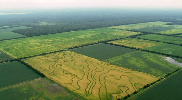
Nowlin said the main objective of the project is to research and develop agricultural applications, using airborne sensor data, in the Mississippi Alluvial Plain (MAP) and Crowley’s Ridge regions.
“We will be collecting field measurements of crop height, elevation, vegetation health indices, soil moisture, water level of flooded fields and storage reservoirs, and analyzing topographic surface accuracy and precision,” he said.
“This will primarily be at existing USDA research locations and in fields and reservoirs with existing flood depth gauges.”
Researchers plan to make flights over the areas they are studying every two weeks into October. The project will continue after the growing and harvest season to the end of December 2020.
Eleven agricultural producers have been invited to participate in the research and development project. Nowlin asked each one to select a field or set of fields of about a quarter-section (120 acres) in area, then share their farming data such as seed varieties, planting rates, fertilizer, herbicide and pesticide applications, yield, and other factors that might affect in-field crop variability.
The main area of interest will be Northeast Arkansas, extending from Lee County north to Missouri and covering at least the primary farming region between the 11 cooperating farmers. The core of their holdings are in Craighead, Poinsett, Mississippi, Crittenden, Cross, St. Francis and Lee counties.
Instruments will capture images using both the visible light spectrum and near-infrared, and will use a light detecting and ranging (LiDAR) laser-based sensor, and synthetic aperture radar (SAR) to determine three-dimensional measurements and representations of the ground surface.
Drs. Michele Reba and Joseph Massey from the USDA’s Agriculture Research Service Delta Water Management Unit in Jonesboro are working closely with Nowlin and his team on the project.
U.S. Rep. Rick Crawford, R-Jonesboro, expressed his support for SPAED because of its potential to improve farming and food security.
“I am excited that Arkansas State, along with Meta Aerospace, are working on cutting-edge technology that will transform the way ag-producers farm in Arkansas and across the country. Without technology such as this, we will lose our global standing as leaders in food and fiber creation and cede our national security to external threats,” Crawford said. “I hope this technology becomes standard practice in our country and will generate additional technologies and careers to support our ag-producers and the American people so we can remain food and fiber secure.”
Much of this year’s work will focus on “ground-truthing,” the process for verifying three-dimensional points on the ground with airborne instrument readings.
“After the 2020 harvest, we will primarily focus on assessing aerial surfaces for optimal flight heights and the resulting granular spatial resolutions of the collected data,” Nowlin said. “We will assess the basic economics of collecting the data every two weeks, and we will develop a list of actionable agricultural applications from these surfaces based on the ground-truth data, interactions with farmers, participating farmer data, and expert advice from collaborators.”
In exchange for their participation in the project, Nowlin’s team will share high resolution elevation surfaces and three-dimensional points of each producer’s farm before March 31, 2021.
“The goal is to give the participating farmers high enough quality points so that they can use them for irrigation planning,” Nowlin added. “Furthermore, once our pilot project is funded we will be engaging with each participant as we develop agronomic applications.”
The researchers will then use this year’s data to design the project’s phase two portion, a two-year pilot program that will evaluate the collection of data, assess the temporal and spatial pattern and quality of the collected data, and work to generate deliverable products from the collected data, Nowlin said, adding he also will be looking for funding for phase two.