Corps, Fort Smith officials hear complaints about river flooding
by July 17, 2019 9:35 pm 2,870 views
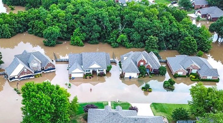
Flooded homes in Fort Smith. (photo courtesy of Austin Collins)
Fort Smith residents wanted answers — lots of answers — at Tuesday night’s (July 17) community meeting for flood-affected Fort Smith residents and businesses. Answers, however, were few.
A number of the 80 or so who attended the meeting asked about U.S. Corps of Engineers policies, specifically when locks will be opened to send floodwaters further downstream. With available technology that can adequately predict rainfall and other conditions and history to base things on, residents questioned why the Corps couldn’t better predict when flooding would occur and take more action to avoid it.
Corps personnel said the answer was simple.
“We don’t act until the water is on the ground.”
Trying to estimate or predict what might happen can lead to disastrous complications along the river, said Chris Roark, executive officer with the Corps of Engineers.
“What if it doesn’t happen and we’ve released the water downstream. Then we’ve caused a drought. Or what if we release, and there is an unprecedented event downstream, and we’ve just caused extreme flooding downstream,” Roark said.
A key component Corps representatives stressed is that the locks and dams managed by the Corps of Engineers on the Arkansas River in Arkansas are not designed for flood control. They are not large enough for this to be the mission. Instead, the mission is for navigation, said Jay Townsend with the Corps of Engineers.
But residents expressed that wasn’t good enough. Residents wanted to know why operating procedures for the Arkansas River in and around the Fort Smith area have not been studied or updated in approximately 30 years. They wanted to know why something is not being done to keep these floods from occurring.
Though the flooding of the Arkansas River in May broke records set in 1945 and is considered an unprecedented event, water levels crested at 34.63 feet in December 2015 and around 36 feet in 1990. With this type of history, residents said they want more current studies completed and policies updated.
“We are project funded,” Townsend said. “We cannot just decide to have a new study. That order has to come from above us.”
That someone above is ultimately the president of the United States and Congress, he added. Others in attendance wanted to know why updated flood maps are not automatically sent to residents living in the flood plains by FEMA. Lady Jane Cohen of Fort Smith said that she did not have flood insurance on her house because it was not thought to be in a flood plain. She discovered after her home flooded, that the flood map had changed 12 years ago and she had not been notified.
FEMA representatives said that when flood maps are redrawn, they are done so at the request of the government by order of Congress and the new maps are communicated with the community involved. The city then communicates that with residents through required publishing through certain media. Maps are not mailed to residents.
“I wasn’t here 12 years ago, so I don’t know exactly what happened then,” said City Administrator Carl Geffken. “But the policy would be to publish it through two places, usually the newspaper and either a television station or something like that.”
Geffken also said the city would work with other agencies to gather information on this year’s flooding, study it, and look at ways to prevent it from occurring again.
“That is something we definitely want. It’s something the city directors want to see done. It’s something the mayor wants to see done. It’s something we all want to do. We have to start with gathering information. We are starting the process so we can have answers and alternatives for the future,” Geffken said.