Fort Smith Banks on Liquid Highway
by July 6, 2012 9:19 am 164 views
Two proposals are viewed by many area leaders as necessary for the future prosperity of both the Fort Smith and Northwest Arkansas regions and the state.
One is the deepening of the Arkansas River system to 12 feet to allow barges to carry more freight. Most of the river is already 12 feet deep, but several spots need dredging to attain that depth.
The other proposal on the boards calls for the building of a slackwater harbor. The term refers to a manmade harbor off the main river channel, out of the flow of currents and barge traffic.
These harbors make loading and unloading goods much easier, and when accompanied by land-based infrastructure such as highways and rails, they’re key components of “multimodal” facilities that can move products nationwide.
The Arkansas River is part of the 445-mile-long McClellan-Kerr Arkansas River Navigation System, also known as MKARNS, which stretches from the Mississippi River to Catoosa, Okla., near Tulsa.
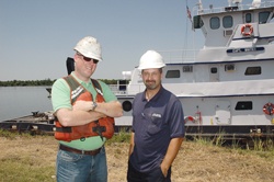
The more than 50 private ports along the system include the Port of Van Buren, owned and operated by Five Rivers Distribution. The company also operates the city-owned Port of Fort Smith, one of five public ports on the MKARNS.
Five Rivers president Marty Shell wants to see both projects brought to fruition, but said the 12-foot channel is a “must,” not just for the Fort Smith and Northwest Arkansas regions, but for Arkansas as well.
“It would allow us to compete against other inland ports,” he said. “It would not only retain businesses that are here, but would bring in new business as well.”
Last year, 10.7 million tons of commodities were shipped on the McClellan-Kerr system, according to a February report from the U.S. Army Corps of Engineers’ Little Rock District, which encompasses the Fort Smith and Van Buren ports. These commodities had a combined estimated value of $3.11 billion.
Tonnage continues to increase, the Corps reports, but cuts in federal funding have delayed improvements to the river system.
Deep Waters
A major proponent of the 12-foot channel project is the Western Arkansas Regional Intermodal Transportation Authority, or RITA. Its director, Mat Pitsch, said that almost immediately after MKARNS opened in 1971 as a 9-foot channel, requests to deepen it to 12 feet prompted the Corps to start looking into that possibility.
The benefits of a deeper channel include more money from hydroelectricity generated by power plants along the system and lower transportation costs to industries, Pitsch said.
Savings on transportation can be passed along to customers and make companies more profitable, he said.
“A lot of communities and industries along the river want that,” he added.
But to keep the channel at 12 feet means dredging out silt and rocks, and that requires disposal sites along the river, Pitsch said.
In March, Garver Engineering prepared an “Arkansas River Channel Improvement Study” for state land commissioner John Thurston. The study’s findings have been given to U.S. senators John Boozman and Mark Pryor, and the rest of the Arkansas congressional delegation, Shell said.
Bill Ruck, Garver’s senior project engineer on the study, wrote that a 12-foot navigation channel already exists along the centerline and most edges of the river channel. Less than 3 percent of the designated navigation channel is less than 12 feet deep.
“In most cases, edge trimming of less than 2 feet in depth will clear the entire marked width for use,” Ruck wrote.
Still, he added, “Arkansas agricultural and other exports are more expensive at seaports than necessary because of this.”
A normal barge “drafts” 11.5 feet when fully loaded, so shippers using the MKARNS in Oklahoma and Arkansas have to send out barges with lighter loads to get them safely downstream.
Due to the physics of displacement, “Shippers on the MKARNS are at a 43 percent disadvantage when competitors on the Mississippi River and the Gulf Intracoastal Waterway operate fully loaded using the same type barges,” according to the study.
So if only 3 percent of the waterway’s area needs to be deepened, why hasn’t it been done already?
Pitsch said he believes “money is the issue.”
No funding for the project was included in the federal budget for 2012 or in the Obama administration’s budget for 2013, according to the Corps’ February report.
Shell estimates it would take about $7 million to $10 million to get the project started.
“Right now the federal government is going through some hard things, and until the government can get itself fixed, I don’t see it going forward,” Shell said. “But I would rank it No. 1 or 2 for the state of Arkansas for economic growth.”
An impetus for moving forward with this project is the expanded Panama Canal. Locks that can accommodate supertankers from Asia will open in August 2014, allowing these much larger ships to bring more goods through the canal to ports on the Gulf and East coasts.
Since the “bluewater” ports, or coastal ports, are already at capacity, Shell said, the “brownwater,” or inland, ports will be needed to handle the increased volume of imports and exports.
“So we’re hoping for a strong future,” he said.
Calm Harbor
A slackwater harbor on the MKARNS would be years away, largely due to the feasibility and environmental impact studies that need to be done and, again, a lack of funding.
RITA recently agreed to pay half the cost, up to $50,000, for the second phase of these studies, Pitsch said. This study largely involves surveying private industries along the MKARNS to see how much need exists for such a harbor.
“The total [cost of the current study] is unknown, but the contract was not to exceed $50,000,” Pitsch said. “If it gets more than that, we have to enter into a new contract.”
RITA asked the Corps to look at four possible sites for the harbor — the Port of Fort Smith, the landing at Ozark, the Crawford County levee site and Lavaca — but only the latter two met the cost-benefit ratio criteria.
The next phase of the project is about a year away, Pitsch said, once the cost-benefit and environmental mitigation studies are done.
“If all the green lights are there, we have to decide who’s going to pay for a public port, or are we going to market it to private developers,” he said. “There’s a lot of directions you can go.”
All that has to be determined before design and construction can even begin.
As to cost estimates for the harbor, “There have been numbers thrown around, but they’re just numbers,” Pitsch said. “It hasn’t been designed yet, and there are many factors still to be determined.
“But some people have estimated $10 million to $15 million, or as much as $20 million.”
When construction might begin is anyone’s guess.
“We know the next phase is estimated to take nine months to a year,” Pitsch said. “That’s the farthest we can see right now.”
A slackwater harbor won’t pose competition for existing ports because they handle different types of freight, Pitsch said.
Local ports tend to deal with “break bulk” freight, or parts, to be assembled into cars or other products.
“A slackwater harbor would allow industries to bring in full units,” he said.
Shell agreed that a slackwater harbor, rather than taking traffic away from existing ports, would bring additional traffic.
“We need to grow the pie to share the pie,” he said.
“I would say one key thing we have that other people don’t have is we have this liquid highway. We have reciprocal railroads. We have a great highway system. We sit in a prime location to have transportation needs met.
“Location drives where these facilities go, and I think we sit in a very prime location.”