Timing not good for farmers with Hurricane Francine
by September 10, 2024 8:16 pm 290 views
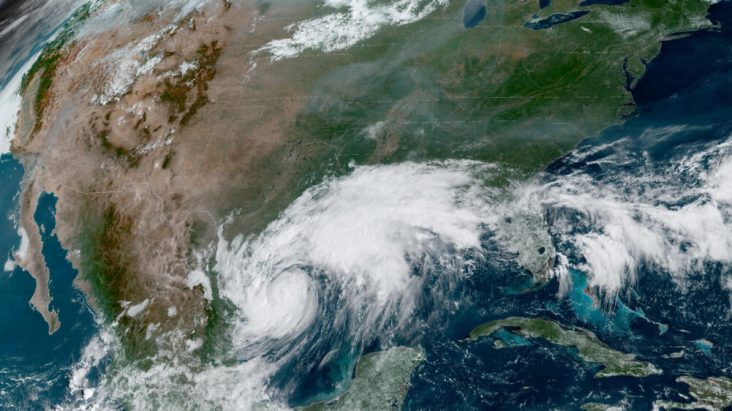
Hurricane Francine is projected to make landfall sometime Wednesday (Sept. 11) in Texas and Louisiana before it barrels north into Arkansas. The National Weather Service is projecting the storm will bring high winds and heavy rains to many parts of the Natural State and it might have a devastating impact on farmers who are in the midst of harvest.
“We never want to gripe about rain, but this timing couldn’t be worse,” said Zachary Treadway, extension cotton and peanut agronomist for the University of Arkansas System Division of Agriculture. “We’ve got guys trying to get rice out, guys trying to get beans out, we’re trying to get cotton defoliated. It’s definitely not a good time for a tropical storm.”
The storm was expected to weaken into a tropical depression by the time it reaches Arkansas on Thursday. Tuesday’s forecast cone covered the eastern half of Arkansas.
“The system is expected to continue towards the state bringing the chance for heavy rainfall, gusty winds, and possibly a few tornadoes Wednesday night through Friday afternoon,” the National Weather Service at Little Rock said.
Cotton plants being blown over is a significant concern.
“Bolls that come in close proximity with the soil are at risk for rot or hard lock,” Treadway said. “Plants that are blown over will straighten up some, but for those that get tangled up, this could take longer.”
Hard lock refers to cotton bolls that either will not open or open very little due to bacteria or fungus.
But the heavy winds aren’t the only issue. With most of Arkansas’ cotton bolls open, rain could threaten exposed cotton.
“If we have a lot of rain on open bolls, the cotton will fall out of the boll. Wet cotton almost looks like it’s dripping off the plant,” Treadway said. “It can dry, but it lowers the cotton quality and makes it harder to pick.”
With cotton harvest around the corner, Treadway said the rain could also keep farmers out of the field when they were set to apply harvest aids, delaying harvest and lowering quality.
As for rice, it will be a race to Wednesday night for most growers, especially those in the Delta region.
“The entire Delta, top to bottom, is set to be on the western side of the eye, which is where we see the most rain,” said Jarrod Hardke, extension rice agronomist for the Division of Agriculture. “From a rainfall standpoint, the bulk of the concern is Wednesday night going into Thursday.”
With Arkansas rice on pace for its earliest crop since 2010, Hardke said the dry, mature plants are at their most vulnerable state right now.
“This is the exact kind of storm that is worst for rice that has been drained and is ready to harvest,” Hardke said. “We don’t have a lot of stalk integrity left. It’s a great thing we took advantage of that early planting window, we did the right thing, but as it goes we planted quicker than we can harvest, creating a bad recipe for those acres that are left.”
According to Monday’s Crop Progress Report, 56% of rice in Arkansas has been harvested, leaving almost half of the state’s crop still out in the field. For rice growers in the Delta, it will be a race to harvest what acres they can before Wednesday night.
“We’ll be pushing it on the early side of harvest for some fields,” Hardke said. “It’s really a game of prioritizing what needs to be harvested first.”
Hardke said high winds and excessive rain could cause lodging, broken panicles and delayed harvest. All coming at peak harvest season for this year’s rice crop.
“Two weeks ago, when plants were greener and not as dry, I wouldn’t have been as worried. Two weeks from now wouldn’t have been so bad,” Hardke said. “But with where our rice is now, I’m just hoping we get lucky and dodge most of it.”