Proposed redistricting map would place Reps. Hill, Westerman in each other’s districts
by September 23, 2021 7:05 pm 1,862 views
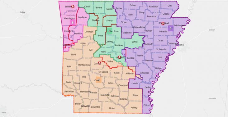
A proposed Congressional redistricting map presented by Sen. Alan Clark, R-Lonsdale.
The House and Senate State Agencies and Governmental Affairs Committees on Thursday (Sept. 23) heard presentations on four Congressional redistricting maps, including one that would move U.S. Rep. French Hill’s home from the 2nd to the 4th District and move Rep. Bruce Westerman’s home from the 4th to the 2nd.
Hill lives in Little Rock, and Westerman lives in Hot Springs. Both are Republicans.
It also would split the state’s most populous county, Pulaski, into three districts and Little Rock into two. The map’s sponsor, Sen. Bart Hester, R-Cave Springs, told Talk Business & Politics he was aware the map as drawn switched the two members of Congress, but it’s still a work in progress.
“I presented the map as is today without that correction so I could say the map is exactly as drawn based on the simple requirement of compactness of geography,” he said. “The presentation of this map and the debate around it today has helped us to get to a map that I think could be close to final.”
Under the U.S. Constitution, U.S. House members are required to be residents of their states but don’t have to live in the districts they represent.
The committees are meeting again Sept. 27 to consider whatever maps other members bring. Sen. Jason Rapert, R-Conway, the Senate chair, said afterwards that at least one other map by Sen. Blake Johnson, R-Corning, is being prepared. No action will be taken, but the meetings are part of the consensus-building process that will lead to a vote on new districts when the Legislature reconvenes Sept. 29.
Lawmakers recessed after their regular session this spring rather than adjourning because they were waiting for population changes provided by the U.S. census. Lines are redrawn every 10 years after each census. They must be substantially equal in population.
The committees spent the most time on Hester’s map in Senate Bill 721, which would divide the state into four corner quadrants.
• The 1st District would be composed of 18 complete counties in northeast Arkansas and part of Pulaski County. That district, represented by U.S. Rep. Rick Crawford, R-Jonesboro, covers eastern and northern Arkansas. Faulkner and White counties would be among those moved from the 2nd to the 1st.
• The 2nd District would cover 22 complete counties in Arkansas’ southeast quadrant along with part of Pulaski County. It would be significantly different than the mostly central Arkansas counties it currently covers, with only Saline and part of Pulaski County remaining in the district. The district would stretch from Garland and Hot Spring Counties eastward to the Mississippi River, from St. Francis in the north to Chicot in the south.
• The 3rd District would cover 10 counties in Northwest Arkansas. Among its most notable changes would be losing Pope and the part of Sebastian County it now covers.
• The 4th District, arguable the least changed district, would cover 24 counties in the state’s western half and Pulaski County. Its most notable change would be the addition of the rest of Sebastian County and the northwest part of Pulaski County, while it would lose Garland County, Westerman’s home.
Hester told committee members he had asked the Bureau of Legislative Research to draw a map whose districts were compact and split as few counties as possible. Only Pulaski County would be split, a result of it being the most populous and centrally located county. Hester said the map was fairer than the map drawn after the 2010 census by Democrats when they were still in control of the Legislature. That map split five counties.
Sens. Clarke Tucker, Linda Chesterfield and Joyce Elliott, all Democrats representing Little Rock, questioned splitting up the county. Chesterfield said Pulaski County residents would be unsure who their representative would be. Tucker said Little Rock would be split into two districts, the 2nd and the 4th. Hester said he would consider changing the boundaries so Little Rock would be represented by one member of Congress.
Several Republicans including Rapert said Democrats in 2011 sought unsuccessfully to protect their seat in the 4th District by attempting to draw a map that included Fayetteville, a gambit known as the “Fayetteville finger.”
Lawmakers also heard a proposal by Rep. Reginald Murdock, House Bill 1962, that also would significantly change the districts. The 2nd would be composed of Pulaski County along with Jefferson County and eastern Arkansas, leading Rep. Aaron Pilkington, R-Knoxville, to ask if the Democratic National Committee had drawn it. No legislators asked questions after Murdock’s presentation.
Two other maps by Sen. Alan Clark, R-Lonsdale, were presented by Rapert. The two would change current districts less than Hester’s and Murdock’s proposals. The map in Senate Bill 722 would little change the 1st District while moving Saline into the 4th. The 2nd would include Pope County and would stretch to the Missouri border. The 3rd would be comprised of only six counties, including Benton, Washington, Crawford and Sebastian. Clark’s other map in Senate Bill 723 would keep Saline in the 2nd while moving Pope to the 4th. Both would split Pulaski County.